Atlas of Palestine 1948
Palestine is one of the most well-documented areas of the world. What makes the Atlas of Palestine unique?
Any Atlas is a graphic representation of data. Unless you are an explorer charting new territory, all atlases are based on existing data. In this sense, the Atlas of Palestine 1948 is not unique. But it is the firsttimethat such massive data on Palestine was assembled in one volume. That is in addition to the analysis of results. Let us not forget that compilation of all this data has a historical-political meaning.
In July 1949, immediately after signing the last Armistice agreement with a neighboring Arab state (Syria), Israel’s first Prime Minister, David Ben Gurion setup a committee of scholars to erase all existing Palestinian names and replace them with Hebrew names. The Atlas saves them from this erasure and puts them back on record.
What was your inspiration for creating the Atlas?
All my adult life, I have been trying to reconstruct my birthplace through photos, maps, documents and oral narrative. It was indelible in my memory, gained in the first10yearsofmylifebeforeIbecamea refugee. That was not enough. I wanted to pass this on to my children, relatives and Palestinians at large in a permanent record. I was very surprised to findawealthofinformationincolonialcapitalsofEurope, especially England, and even in Istanbul, the old capital of the Ottoman Empire. Soon it became clear that this information can and should cover all of Palestine. Hence the shift from my birthplace to my homeland.
Assembling such a large volume of information is not a simple task. What kind of problems did you face?
The problems were immense. First to locate documents. Some references are well-known, like the Public Records Office. Even in well-known sources like the Royal Geographical Society, you need days to know that such valuable papers, like those of Bramley Jennings, the Sinai Inspector, actually exist. It is a common misconception to think that the Mandate papers for Palestine exist in one building. They are scattered in so many places that a book – known only to a few researchers – was compiled to list the location of these papers. Trips to the UN in New York were made to obtain copies of Armistice maps; to Munich to visit the War Museum; to the Bibliothèque Nationale in Paris and others. The main problem is that a single author has no authority to demand documents from states. In fact, the word Palestine was often a warning signal to librarians, not to give you information.
This of course created technical problems. We had to deal with small-scale maps and minimize errors as best as possible. If a large scale map was discovered, we had to repeat the work. The learning process took so long, especially since material and manpower resources were meager. It would have taken half the time of 10 years that it took to prepare the Atlas if such resources were readily available and sources of information were instructed to be cooperative.
What were some of the interesting discoveries that resulted from the mapping process?
To spend months and years peering over these maps is a very rewarding experience. Tens of thousands of place names spell the vocabulary of Palestinian life, especially in villages. Not only ancient names from Canaanite times, reproduced in holy books, but locally-carved names were most interesting. Here is where the horse (of an important man, possibly) fell and its rider killed. Here is where the most beautiful bride was wed. Here is where the holy man (weli) was buried. Here is the tell from where Napoleon viewed Acre which he could not conquer. A myriad of historical and social events were immortalized in these names whose copy-right, so to speak, is reserved for those Palestinians who made that history.
The most obvious and saddest impression is the staggering dimensions of the Nakba. In every spot you look at, you know there were people with their own local history and geography that sustained them for centuries. Now they are refugees living in exile for over half a century. Numbers alone cannot fully describe this human experience. Life has been snuffed out of 675 towns and villages. But in every one of them, indeed in every house and in every plot of land, life was destroyed and there is a story to be told.
Can you describe some of the interesting or unknown aspects concerning the borders of Palestine?
Although demarcated at different times by different people, Palestine’s borders have much in common. In all cases, they were created by Colonial powers, competing for a larger piece of Arab land. In all cases, the local population was never consulted. When they agitated or rioted, a little allowance was made to that. In all cases, the borders shattered the life of a homogeneous community, separated them from each other, which ultimately gave them different nationalities.
Nowhere is this more vivid and dramatic than the split of the population and their land in demarcating the Armistice Line in the West Bank and Gaza Strip. Although this line is strictly not a border, it acted as one when Israel wanted to prevent the Palestinians from returning home and it became irrelevant when Israelis – soldiers and settlers alike, wanted to cross it.
The Atlas analyzes the different sources for Jewish ownership of land in Palestine before the Nakba. How do the different sources compare? What were your conclusions after examining the different sources?
Jewish immigrants were keen to record every piece of land they acquired in Palestine to prove their presence and to show their rich donors in Europe how the money was spent. The British Mandate policy created many land laws conducive to acquiring more land. In fact Zionists officialsandBritish-Zionists,
such as Norman Bentwich, formulated these laws. But there was much forgery and violation of the Mandate laws especially after 1940. This is evident by comparing the various Jewish and British sources and analyzing the results, as was done in Part I of the Atlas. There is anywhere between 250,000-400,000 dunums (1 dunum = 1000 m2) which were fraudulently assumed under Jewish control before 1948. In later years, some Israeli authors admitted that and showed how it was done.
But this is not the point. The difference between the reliable figureof5.4percentofJewishownershipin Palestine and the exaggerated figureof7percent,isirrelevant,becauseneithergivestheZioniststhesupremacy over Palestine and the right or excuse to expel an dispossess the Palestinians.
The real cause of the Nakba is the importation of Jewish immigrants, most of them of military age, especially after WWII. The Mandate allowed them to build their institutions, especially the Army. During this period the Jewish population increased 10-fold, from 56,000 in 1917 to 600,000 in 1947. They were able to deploy 65,000 armed soldiers at the onset of Plan Dalet in April 1948. This increased to 120,000 in January 1949. That is 20 per cent of the population, an unprecedented percentage. A typical country has 1-2 per cent of its population in the armed forces. The Nakba was inevitable. Welcome to our website featuring the best free chat girl porn rom adult conduct when video chatting with
The maps in the Atlas also contain interesting data on the infrastructure, public amenities and religious sites. How did you findtheirlocation?
The data on infrastructure, public buildings and religious sites are indeed interesting. This information is derived from large scale maps, when available, which show government or public buildings. Frequently they are given in abbreviated forms or symbols. They were shown because they were of particular interest to the British administration. It is amazing how many public buildings were built (or assigned to existing buildings) by the British Mandate in such a relatively short period of 28 years (1920-1948).
The religious sites were carefully marked as a reflectionofthelong-timeinterestintheHolyLand,sincethe well-known survey by the Palestine Exploration Fund, which started in 1871. The number of the shown landmarks in the Atlas is a conservative estimate, as shown by a new fieldsurveyofreligioussites.
The surprise is the number of military installations (airports, airfields,camps)whichtheBritishleft.Thesewereshown on photos but were omitted from maps. All of them were seized, and used effectively, by Israel.
That Palestinian towns and villages were depopulated and their land and property seized by Israel is now generally known. But the fact rarely mentioned is that Israel seized a full civil and military infrastructure of a state, almost over night. An instant state was functioning on the morning of 15 May 1948. A Jewish civil servant of the Mandate would go to work on 15 May and find all the records, maps, documents and furniture in his office intact–minus his Palestinian colleagues who became refugees.
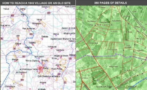
One of the novel features of the Atlas compared to other maps of Palestine is the use of aerial photos. Can you describe how you used these photos and what they tell us about Palestine?
The use of aerial photos has a tremendous impact on the visualization of life in Palestine. Line drawings are accurate but lifeless. They can be interpreted by professionals, not so easily by laymen. Photos show gardens, fields,wadis (valleys), clusters of houses, mountains. All such features have an intimate relationship to the life of Palestine. They are immediately recognized by a refugee. A grandfather can tell his grandchildren to see, not just to imagine, his village. On a personal note, I could see my father’s house, his orchard and my school. Such features cannot be erased from my memory and, now, can be shared with my children.
Anyone who takes a quick look at the Atlas, even a non-Palestinian, would recognize there were people who built these towns and tilled these fields.Thus,theinsidiousliethat“Palestineisalandwithoutpeople” becomes apparent. No doubt the Zionists knew this well but they wanted to make it so. They succeeded in the Nakba of 1948.
It is often said by those who oppose the return of Palestinian refugees that “the clock cannot be turned back”. What does the Atlas tell us about the future?
At least since the nineteenth century, Palestine was plagued by adventurers, spies, colonialists and imperialists which led ultimately to the destruction of Palestine. It is a mixed blessing that this has led also to Palestine becoming the most documented Arab country. The Atlas shows this clearly, not only in terms of land ownership and population distribution but also in the name, character and use of every square kilometer. A huge database was created. It is now linked with every camp and place of exile.
When this is linked with today’s satellite maps and data about the present situation, it becomes a straight forward exercise, at least from an analytical point of view, to restore homes and property to their owners.
As has been demonstrated earlier (see From Refugees to Citizens at Home: The End of the Palestinian-Israeli Conflict, London: Palestine Land Society and The Palestinian Return Centre, 2001), the return of the refugees is physically quite feasible. It is interesting to note that no Israeli scholar has challenged this argument on this score.
The right of return has a solid basis in international law. Currently available data will be of considerable value to the modalities and mechanisms established to implement the right of return. As to “the clock cannot be turned back”, we take a leaf from Herzl’s book and say: it is easier to correct a wrong done than to create it against all odds.
The production of the Atlas is a major undertaking. Is there more to be done in terms of mapping a solution for Palestinian refugees?
Yes there is a lot to be done. First an Arabic language edition is absolutely necessary. This should be an affordable edition, perhaps a number of small size volumes, each representing a district or a region. The Arabic version requires not merely translation. Far from it. It needs to verify the spelling, accent and emphasis on syllables of the original Arabic names. This requires research in Arab sources, but more importantly, fieldtripstovariousregionstoverifythenames.
Further, it is necessary to link this information to locations of exile, in order to reconnect various communities to their places of origin. Another useful application is to produce a guide booklet, showing old and modern maps, which can direct refugees to their old villages and sites.
The key task, which is technically quite feasible, is to link the massive data available for Israel today with the Palestinian data now saved from oblivion. This will surely secure the future of Palestine and Palestinians no matter long it takes. Leaders disappear, political regimes, however oppressive, dissolve one day but records and the people do not die.
For more information on how to obtain a copy of the Atlas of Palestine 1948 visit the website of the Palestine Land Society, http://www.plands.org.
Dr. Salman Abu Sitta is the founder and president of the Palestine Land Society.